

— Photo courtesy the city of Newport Beach ©
Officials have big plans for Big Canyon, and restoring and protecting the habitat are at the top of the list.
Newport Beach hosted an informational meeting about the Resource and Recreation Management Plan for Big Canyon Nature Park on Wednesday.
Along with city staff, officials from Irvine Ranch Conservancy and environmental consultant Dudek presented the plan to a small crowd in the friend’s room at the library.
“Big Canyon is a very interesting and unique place within the Newport Back Bay area,” said Riley Pratt of the IRC.
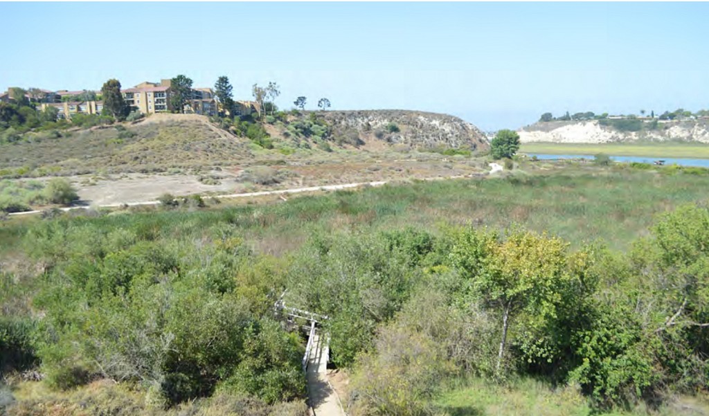
It’s the largest remaining natural canyon within Newport Bay, he explained. It supports a rich diversity of plants and animals, but it’s been degraded over the years, Pratt said.
The plan is meant to help steer restoration activities, said Newport Beach Assistant City Engineer Robert Stein.
It provides a comprehensive long-term plan for the management of Big Canyon, Pratt explained. The area is meant to be primarily a reserve for conservation purposes, but also with appropriate enjoyment and recreation that is compatible with that goal.
Officials aim to enhance the habitat while identifying, preserving and protecting the unique resources Big Canyon has to offer, while integrating passive, appropriate recreational uses.
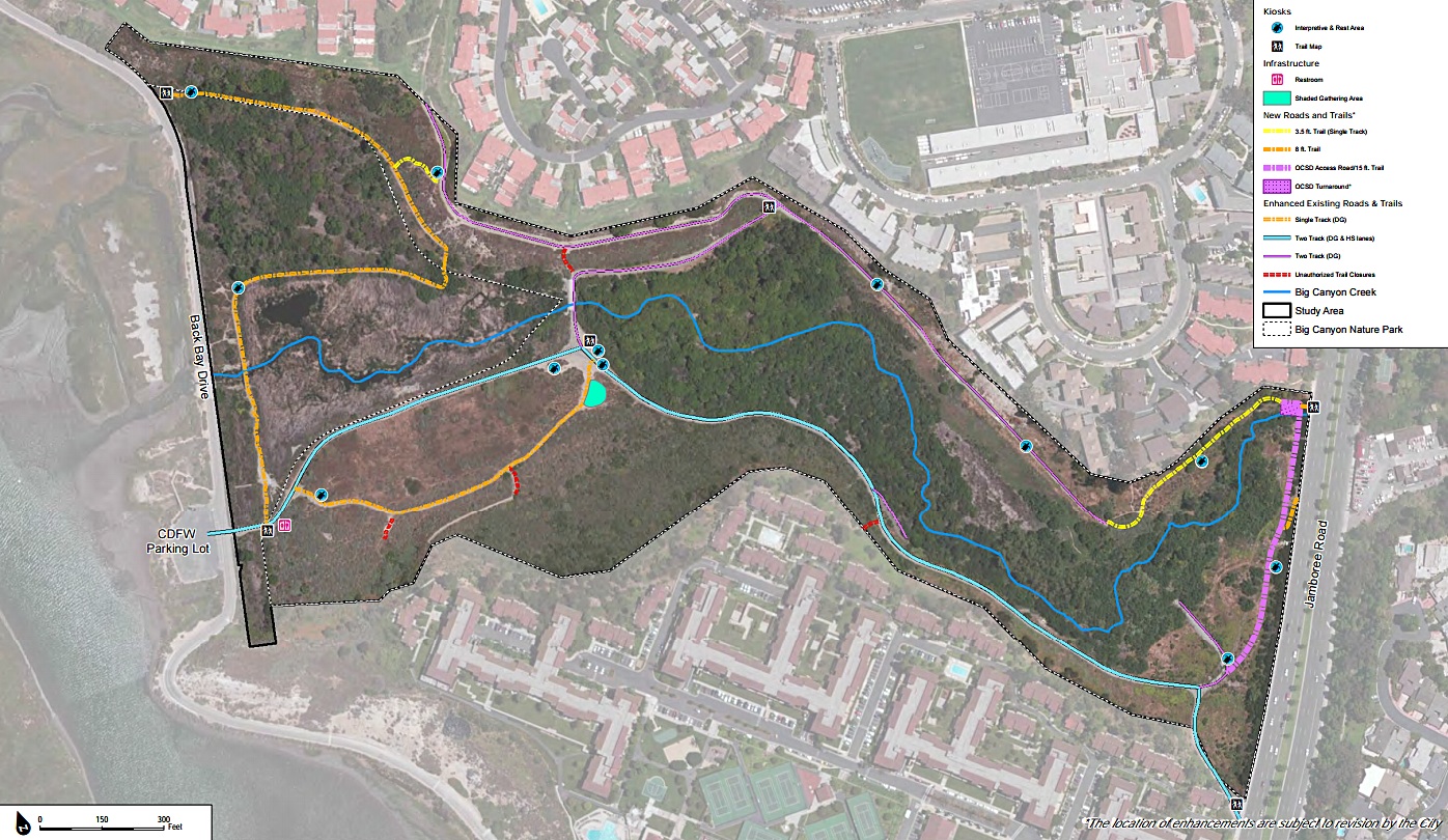
The proposed plan would remove non-native, invasive plant and wildlife species, enhance and repair trails, add officials trails and an entrance, restrooms, and small recreational features.
The plan is also a partnership between several stakeholders, including the Newport Bay Conservancy and the California Department of Fish and Wildlife.
Implementing the entire plan could cost between $7 and $9 million, Stein said. It will be primarily funded through grants and Measure M funds, not the city’s general fund, he noted.
It’s going to be a big project and will take several years to complete, Stein added.
In the long term, it’s going to look much better and be a healthier habitat, Pratt said.
“It’s going to be a real facelift for the whole region,” he said.
They are currently collecting public comments and review of the plan. There may be some modifications before it is finalized.
Prior to creating the plan, they extensively reviewed the documents that currently manage Big Canyon, studied the wildlife and plant life in the area, mapped out the current vegetation community, rare and listed plant and wildlife species, surveyed for invasive species, sampled the soil, evaluated the public access and recreational opportunities and needs, and more.
Results from surveying the plant and animal life were a bit surprising, said Ryan Henry of Dudek. They found that the native to non-native ratio of the 64 total plant species is about half and half, Henry noted. The wildlife ratio was much different, with about 95 percent of the 66 total species being native to the area.
There are several challenges to implement the plan, Pratt said.
The American bullfrog and Brazilian pepper tree are two of the biggest culprits. Both are non-native, invasive species that are very dominant in the habitat. The bullfrog is “voracious” and will “annihilate” other species in the environment, Henry commented.
Pepper trees are resilient, Pratt said
“When you’re in there, there is an illusion of lushness, but it’s almost dead quiet,” Pratt said. “It really doesn’t support much diversity, in terms of wildlife habitat.”
The diversity of animals and plant life really picks up once you leave the shadow of the pepper trees, he added.
The pepper tree forest also attracts “other types of activities,” Pratt said, like people using drugs, drinking, and making encampments.
There are also several unauthorized trails, or “social trails,” Pratt said. The social trails get used a lot and over time erode, which can be dangerous, and they bisect habitat, he said. They can be challenging to remove, he added.
The plan includes closing several of the social trails and encourages the resurfacing of authorized roads and trails with decomposed granite or similar surface that is more attractive, more functional for recreational users, and less prone to erosion and weed growth.
It also suggests adding fencing to designate trail borders, kiosks with both informational and interpretive signage, benches or informal gathering areas, and overlook areas. It also recommends adding restrooms near the current parking lot along Back Bay Drive.
One of the most discussed features of the plan was the trail that connected a utility road and the existing trail in the northeast corner of the park. The addition of an official entrance at that location and the new trail path would increase activity in that spot, which is close to several homes. Several residents voiced their concerns for the proposed change, which would have people walking past their backyards and could see in windows, as one local pointed out.
A few other residents questioned the proposed plan as well, for a few reasons,
“I’m all for restoration of plants and giving a place for flora and fauna to flourish,” said local Penny Wilton, “but I’m not in favor of any development.”
There are plenty of recreational places within the city (and nearby) for people to visit, Wilton noted.
Several people likened the project to the restoration of Buck Gully.
“This whole area has gone down hill,” ecologically, said Peter Fuhrer of the Newport Bay Conservancy, “it needs to be saved.”
For more information, visit newportbeachca.gov. View the draft plan here
— Photo illustration courtesy the city of Newport Beach ©


Where’s the funding coming from? Not one mention of the urban runoff laced with toxics that comes into the North East end. Like Newport Coast being overwatered daily with reclaimed water that IRWD has to get rid of, loaded with salts (plus it ends up in the ASBS areas which is against the law). The water needs to be stopped or diverted, it comes from the West end of the reservoir and picks up Big Canyon Golf course and residential irrigation, goes under Jamboree Road, into the canyon, then into the upper bay. I’ve sat at many presentations of this nuisance flow and canyon park mitigation and wonder how much it costs taxpayers grant or no grants not to mention IRWD (The Irvine Company) hand in the mix.
Reduce the flow of water, take out non-native plants and put in native plants and it will take care of itself, like it did before development started.
With all the knowledge sitting at many committee tables this is the same broken record, you also need to look into why past efforts have failed? Water, plants, some frogs and turtles, whats so difficult?
Are they planning on using glyphosate?? A known carcinogen?