

— Photo by Sara Hall ©
The latest efforts on the planned Lower Newport Harbor dredging project include a potential big “hole in the harbor.”
Newport Beach Harbor Commission heard the update during a meeting Wednesday.
The purpose of the dredging project is to restore the harbor to “design depth” to provide necessary navigation and improve tidal flushing.
City staff’s goal is to dredge now and then “never have to think about a major dredging project again,” explained Public Works Manager Chris Miller.
In partnership with the Army Corps of Engineers, the city plans to dredge approximately 1.2 million cubic yards of sediment starting in 2021 (in an ideal world, best case scenario, and dependent on funding, according to Miller). This is phase two, the first phase in 2012 dredged 600,000 cubic yards.
“It’s a big project and it’s very expensive,” Miller said.
Council has funded all initial efforts to-date, Miller confirmed. Staff is lobbying the federal government for full funding, which is a challenge in itself, he commented.
“It’s a partnership,” Miller said.
Previous estimates have the price tag of upward of $23 million.
If the removed sediment is course grained sandy material and meets quality criteria, then it is reused within the local beach zone. If the material is fine-grained and meets quality criteria, then it is disposed at an EPA approved disposal site called LA-3 about 6 miles from the harbor’s entrance.
— Photo by Sara Hall ©
About 90 percent of the sediment in the harbor is characterized as “suitable,” as evaluated by the EPA, Army Corps, California Coastal Commission, and more.
Most, about 850,000 cubic yards, of the material is suitable for open ocean disposal and will be headed to LA-3.
The “beach-quality” material, about 70,000 cubic yards, will be disposed in the “near-shore” zone, just outside of where the waves break therefore letting mother nature do its job, Miller said.
The other 10 percent, nearly 100,000 cubic yards, is deemed “unsuitable material,” he explained. It’s generally the responsibility of the local agency, not the Corps.
“We have to figure out what to do with (that material),” Miller said.
Out of their very limited options, they are strongly considering a process called Confined Aquatic Disposal.
The proposed CAD project includes a plan to dispose of some sediment within the harbor, essentially digging a big hole, filling it as the dredging process moves forward, using an interim cap and then a final cap can be placed once it is full. Capping is the most critical part of this concept, he noted.
“In the end, it is just a hole in the harbor,” Miller joked.
It’s not a new concept and preferred by a number of agencies, Miller pointed out.
We’re looking for a ‘Yes’ from the Coast Guard,” on this project, Commissioner Bill Kenney noted with respect to repositioning the existing anchorage.
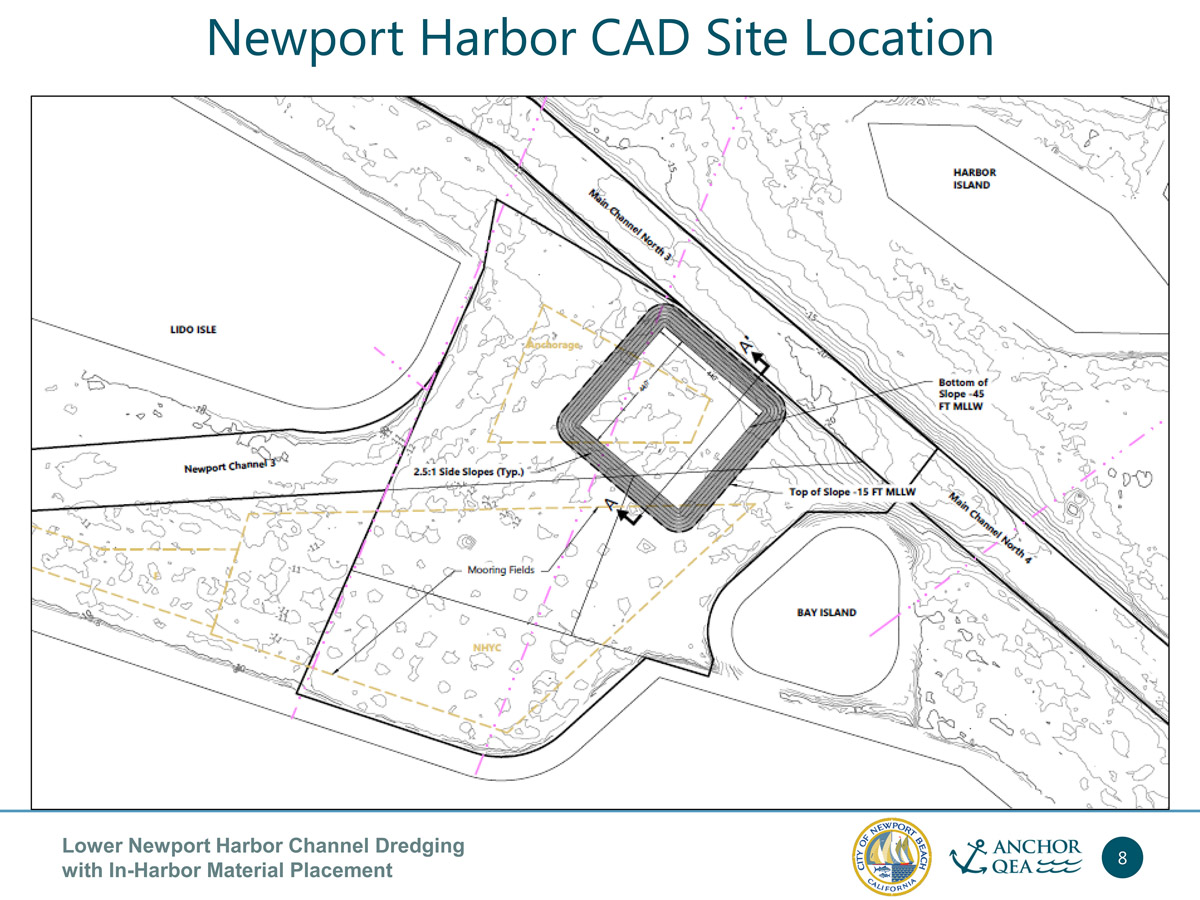
— Map courtesy city of Newport Beach
“There’s no other option (than to move the anchorage),” Miller replied.
Newport Harbor CAD site is located by the anchorage, between Lido Isle and Bay Island, just off the main channel.
But there are other reasons this works. It’s spaced evenly between the areas where the material will be dredged from, so it’s practical. Also, square box is the most efficient shape when digging underwater, and this site allows for that, he explained.
To fit 150,000 cubic yards — 100,000 from the federal channel and an additional 50,00 to accommodate other material elsewhere in the harbor to assist homeowners and marinas — the hole would need to be about -47 feet, Miller explained.
“Your square box needs to be pretty big,” he said.
This process will educate the community to the project they’ll eventually be proposing, Miller said. The CEQA process only covers the CAD portion.
Public scoping meeting at 6 p.m. on Dec. 4 in the Friend’s Room in the Main Library.
It a chance for the community to let city staff know how they’re feeling about this project, Miller said. They will gather public comments and incorporate them into the draft EIR
Staff plans to start applying for permits in spring.
The proposal is for 10 years for the CAD to be open to assist other harbor homeowners or marinas who may want to take advantage of a placement area, Miller noted. Planning to dredge takes time. It may take less, but staff wants to plan to be able to use the CAD site for that long, if needed.
“That’s a moving target,” he added.
The goal would be not to disrupt the anchorage. Hopefully they can work around it an find an alternative, Miller said.
They considered other CAD locations, Miller pointed out, including on the south side of Via Lido Soud and near Marina Park. After considering others, they decided on the most central location and best suited for the project.
It’s a matter of finding a space big enough to dig, he said.
There will be a public scoping meeting on the project on Dec. 4 in the Friends Room at the Central Library (city calendar posting here: newportbeachca.gov/Home/Components/Calendar/Event/60142/72?curm=12&cury=2019 )
For more information, contact Chris Miller at (949) 644-3043 or cmiller@newportbeachca.gov


